Union of Intersections - Solution
Written by Nishant Pappireddi
Answer: PHILIPPINE SEA
The first step is to follow the sequence of instructions. The city whose citizens can vote for presidents but not for senators is Washington DC, so that’s where the journey starts. Each numbered set of directions ends in a different state:
| Instruction Number | Instruction | Remarks |
|---|---|---|
| 1 | Cross via a land border into a neighboring state; The capital and the largest city in this state are adjacent to rivers that exit into the same body of water; One end of a canal is located in this same state and exits into the northern part of this body of water; The other end of this canal exits into a river after crossing another state; Travel to the first state whose capital is upstream along this river. | The border between DC and Virginia is the Potomac River, so crossing a land border must lead into Maryland. Annapolis and Baltimore, the capital and largest city in Maryland, are adjacent to rivers that exit into the Chesapeake Bay. The Chesapeake and Delaware Canal connects the northern part of the Chesapeake to the Delaware River, after crossing through Delaware. The first state capital upstream along the Delaware River is Trenton, New Jersey. |
| 2 | From this state's southernmost point, go due west and travel to the 6th state in that direction, crossing through two bays on the way. | New Jersey’s southernmost point is Cape May. A line starting at Cape May and going due west crosses Delaware, Maryland, Virginia, West Virginia, Ohio, and Kentucky. On the way, this line also passes through the Delaware Bay and the Chesapeake Bay.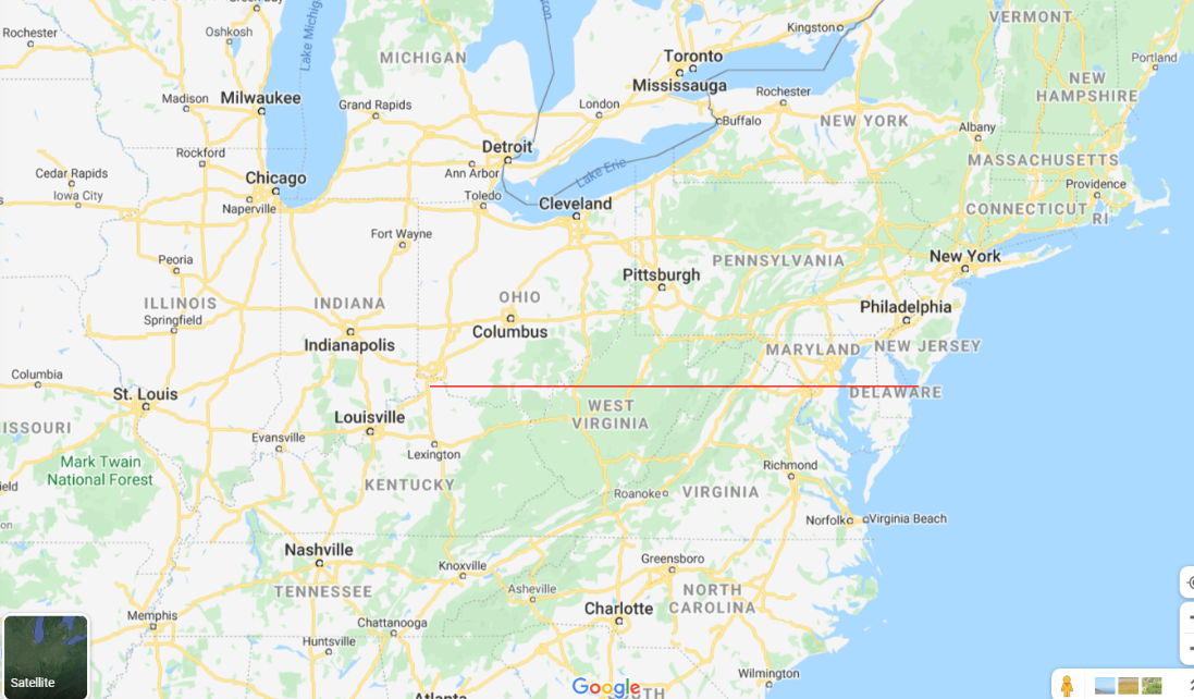 |
| 3 | The smallest border between this state and another state contains a point where one river flows into another; From this point, go upstream along the latter river until you reach the second instance of a tributary river sharing a name with a state flowing into this river; This tributary river is eventually connected by canal to a large city; From this city, go about 210 miles in a straight line to reach a city that shares the name of a Spanish city; This city is on the shore of a major body of water; This body of water shares its name with another city on its shore; Travel to the state this latter city is in. | Kentucky has the smallest border with Missouri, and this border contains the point where the Ohio River flows into the Mississippi River. Upstream of this point along the Mississippi River are the points where the Missouri River and the Illinois River flow into the Mississippi River. The Illinois River is connected to Chicago, Illinois via the Des Plaines River and the Chicago Sanitary and Ship Canal. Chicago is about 210 miles away from Toledo, Ohio, which shares its name with Toledo, Spain. Toledo is on the shores of Lake Erie, which shares its name with Erie, Pennsylvania. |
| 4 | A river begins in this state's 2nd largest city; Follow the river until it eventually reaches the sea; Travel to the first state due east of this estuary. | Pennsylvania’s 2nd largest city is Pittsburgh, which is where the Ohio River begins. The Ohio River flows into the Mississippi River, which eventually flows into the Gulf of Mexico southeast of New Orleans, Louisiana. The first state east of this estuary is Florida. |
| 5 | This state's most populous county was originally named after a person; Travel to the state this person was born in. | Florida’s most populous county is Miami-Dade County, which was originally just Dade County. This county was named for Francis L. Dade, who was born in Virginia. |
| 6 | From this state's capital, go along a straight line past a city in the same state that shares its name with a large Egyptian city; About 80 miles past the latter city along this line is a city in another state that is named for a British city; The name of this city is contained in the name of a major city in a neighboring state; From the easternmost point of this neighboring state, go straight northeast until you reach a state; Travel to that state. | Virginia’s capital is Richmond, and the Virginian city which shares a name with an Egyptian city is Alexandria. Along a straight line from Richmond to Alexandria, the city of York, Pennsylvania lies about 80 miles past Alexandria. York is a substring of New York City in neighboring New York. The easternmost point of New York is Montauk, Long Island. The state due northeast from here is Rhode Island. 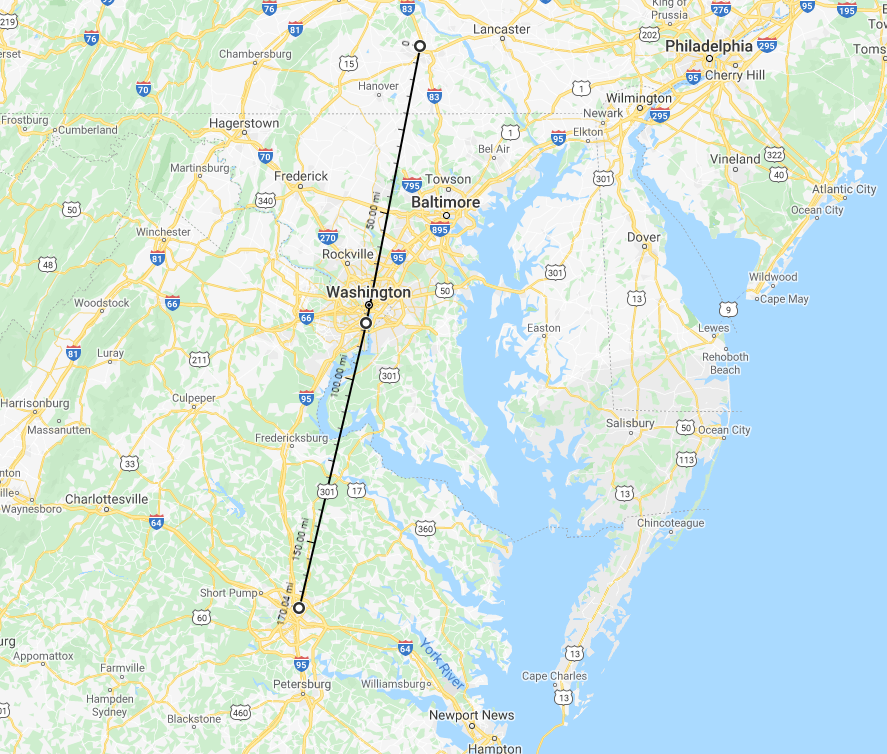 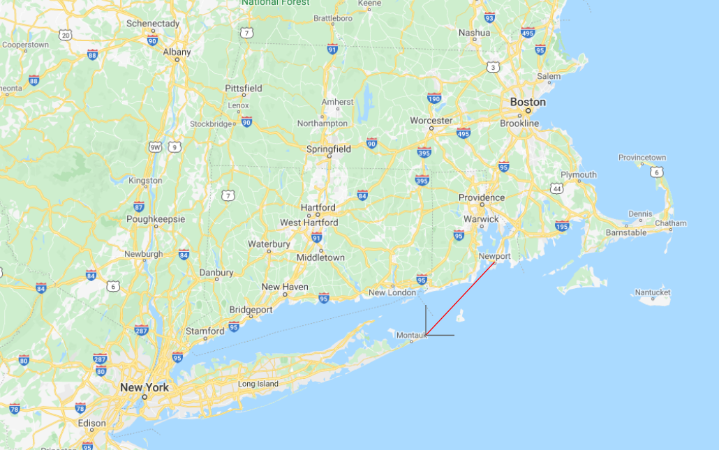 |
| 7 | The largest city in this state is about 70 miles away from a pair of neighboring towns in another state, which are named after alternate names for the same Irish city; This new state's entire border with another is along a river; Travel to the last state this river passes through before reaching the sea. | Rhode Island’s largest city, Providence, is about 70 miles away from Londonderry and Derry in New Hampshire, which share their names with Londonderry/Derry, Northern Ireland. New Hampsire’s border with Vermont is along the Connecticut River. The last state this river flows through is Connecticut. |
| 8 | Travel to the coastal state with the smallest ocean coastline, which is 2 states away from this state. | The coastal state with the smallest coastline is New Hampshire, which is 2 states away from Connecticut. |
| 9 | From the northernmost point of this state, go due west until reaching another state; The largest city in this state is about 100 miles away from a city named for a British city; Travel to the first state that is encountered due east of this latter city. | The first state due west from the northernmost point of New Hampshire is Michigan, whose largest city is Detroit. Detroit is about 100 miles from London, Ontario, in Canada. The first state due east of this London is New York. |
| 10 | From the capitol building in this state's capital, go in a straight line for a certain distance to reach the capitol building in the capital of the largest neighboring state; Travel to the state which contains the point double that distance along the same line past the second capital. | New York’s capital is Albany, and its largest neighboring state is Pennsylvania, whose capital is Harrisburg. The distance between the state capitols in Albany and Harrisburg is 231 miles. Further along this line, 462 miles past Harrisburg, lies a point in North Carolina. 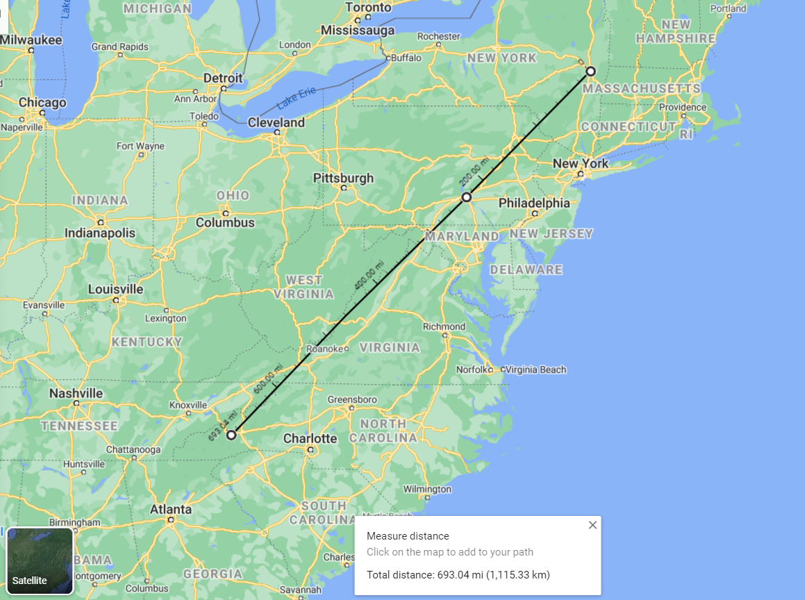 |
| 11 | The largest city in this state is one end of an Amtrak route, and the other end is in another state; Travel to the state this other state shares the 2nd-longest border with. | North Carolina’s largest city is Charlotte, which is on one end of the Amtrak Carolinian route. The other end of this route is New York City, and the state that New York has the 2nd-longest border with is Vermont. |
| 12 | This state's border with a neighboring state is a single straight line; A river flows through the capital of this neighboring state; The name of this river is contained in the name of the largest city of a coastal state; Travel to this coastal state. | Vermont’s border with Massachusetts is a single straight line. The capital of Massachusetts is Boston, through which the Charles River flows. Charles is a substring of Charleston, which is the name of the largest cities in West Virginia and South Carolina. West Virginia is landlocked, so the only coastal state is South Carolina. |
| 13 | Go to the state that borders all states this state borders; The river on the border between this state and two other states has its source in yet another state; The river on the border between this state and two other states has its source in yet another state; Going due east from this river source, you will pass through 2 other states before reaching the ocean, both of which start with the same letter; Travel to the state the 2nd state was once a part of. | South Carolina borders North Carolina and Georgia. The only other state that borders these two states is Tennessee. The border between Tennessee and Arkansas/Missouri is the Mississippi River, whose source is Lake Itasca, Minnesota. A line due east from this source travels through Michigan and Maine before reaching the ocean. Maine was once a part of Massachusetts. |
Now that all the states have been identified, the next step is to notice that all the italicized facts about these states are incorrect, and to find the correct numbers. The final step is to look at the streets of Washington DC. The DC street grid consists of vertical numbered streets, horizontal lettered streets, and diagonal avenues named after states. The Capitol Building is the origin of the grid, with numbered streets increasing to the west and to the east. For each of the 13 sets of instructions, we find the intersection or near-intersection between the state avenue corresponding to the state the instructions end in and the numbered street represented by the difference between the fake and real numbers for the italicized fact (with negative numbers representing streets west of the Capitol and positive numbers representing streets east of the Capitol). In each case, the intersection of these two streets also lies on or near a lettered street:
| State / State Avenue | Property | Incorrect Number | Correct Number | Difference/Numbered Street | Lettered Street |
|---|---|---|---|---|---|
| New Jersey | Total number of seats in both houses of state legislature | 116 | 120 | -4 | P |
| Kentucky | Number of counties | 136 | 120 | 16 | H |
| Pennsylvania | Number of seats in lower house of state legislature | 183 | 203 | -20 | I |
| Florida | Number of electoral votes | 39 | 29 | 10 | L |
| Virginia | Area in thousands of square miles (rounded) | 16 | 43 | -27 | I |
| Rhode Island | Year 27th Amendment ratified | 1980 | 1993 | -13 | P |
| Connecticut | Highest point in feet | 2360 | 2379 | -19 | P |
| New Hampshire | Year first voted for GOP presidential candidate | 1832 | 1856 | -24 | I |
| New York | Population rank of state's largest island in the US | 1 | 1 | 0 (Capitol Street) | N |
| North Carolina | Population rank of state's largest city in the US | 16 | 15 | 1 | E |
| Vermont | Number of seats in upper house of state legislature | 19 | 30 | -11 | S |
| South Carolina | Year of admission to the Union | 1793 | 1788 | 5 | E |
| Massachusetts | Number of Congressional representatives | 19 | 9 | 10 | A |
The lettered streets spell out the answer, PHILIPPINE SEA.
Author's Notes
The original version of this puzzle was within a mini-hunt puzzle that had mini-puzzles for major cities in the Acela Corridor. The intro round puzzle "Island Metric" was based on New York City. This one was based on Washington DC, and originally just showed pictures of states with numbers in them to represent the intersections between state avenues and numbered streets. Once it became its own separate puzzle, I needed to add another step to clue the intersections. I first tried using clues that uniquely match exactly two states, whose intersections would be at lettered streets, but a number of common letters were impossible to extract with this method. Therefore, I went back to cluing a state and a number. One of the editors suggested cluing states by a sequence of instructions, similar to the infamous MIT Mystery Hunt Puzzle “First You Visit Burkina Faso” (though with much easier steps). We then came up with the idea of cluing the numbered streets by giving quantitative “fun facts” that differed from the correct number by the desired street number. Since all the large state avenues are named after the first states in the Union, the journey only went through the eastern half of the country, but it was still really fun coming up with the paths between each consecutive pair of states.